|
Introduction:
The McDowell Mountains in
northeastern
Phoenix host one of the largest known landslides in Arizona. The entire
landslide is within the McDowell
Mountain Regional Park preserve (Figure 1) . Discovery
of this large feature took place during the construction of a
learner-centered
education course funded by the Arizona Board of Regents.
The slide is named in honor
of former
ASU Professor of Geography Melvin Marcus. A world-renowed
physical
geographer and student favorite, Professor Marcus passed away in 1997
while
leading class field trip in the Rocky Mountains.
Check
out this Channel 12 News video clip on the Marcus Landslide: Click Here
|
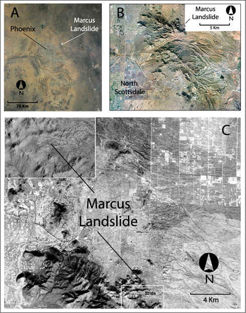
Figure 1. The Marcus
landslide at different
scales.
A) A satellite
image
placing Phoenix in geographic context with the Marcus landslide
(courtesy
of Earth Sciences and Image Analysis Laboratory, NASA Johnson Space
Center).
B) A remotely
sensed
image of North Scottsdale and the McDowell Mountains with respect to
the
Marcus Landslide (courtesy of ASU).
C)
Location
of the Marcus landslide with respect to growth in Scottsdale,
Arizona.Note
how the development is starting to grow out next to very steep slopes
on
the eastern side of the McDowell Mountains, even though the landslide
itself
rests in a land preserve.
|
|
Landslides litter steep
unstable hillslopes
across Arizona. The Grand Canyon in northern Arizona hosts
thousands of landslides, with innumerable failure prone slopes and
cliffs
(Figure 2). In fact, the Surprise Canyon landslide in western
Grand
Canyon remains the largest discovered landslide in the state.
|
Figure 2. A Landsat
image of
the Grand Canyon, courtesy of NASA, merged with the topography.
The
rock fall image, caught by Niccole Cerveny, illustrates what happens
when
very steep slopes are continuously undercut by river erosion.
|
The McDowell Mountains have
one important
thing in common with Grand Canyon, steep hillslopes. The
Marcus
landslide failed along plane with a very steep angle of 33
degrees.
The presence of the Marcus landslide cautions against unwise
development
next to steep slopes of Phoenix mountain ranges.
The
Marcus
Landslide is technically called a rock avalanche. The Marcus
landslide
is among the biggest rock avalanches called sturztroms with a volume
over
7 million cubic meters. The slide mass extends about one
kilometer
from the mountain front with a width of 0.5 kilometers. The
source
exhibits classic features of large landslides of breakaway scar and
fall
zone (Figure 3).
|
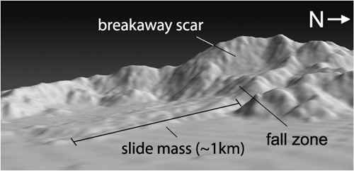
Figure 3. A
west-looking view
of the Marcus landslide from a height of 200m, constructed from a 10m
resolution
digital elevation model in MicroDEM. There is no vertical exaggeration.
Ripples in the foreground represent DEM artifacts.
|
This virtual field provides
a tour
of the Marcus Landslide intended for anyone interested in desert
geomorphology
(geomorphology is the science of how the earth's landscape is
sculpted).
This virtual field trip is more than just a set of pretty pictures,
although
you can certainly just look at the photos. We explore reasons for
landslide failure, the probable age of the landslide, and classic
features of large landslides that you can see on the Marcus
Landslide.
But like any other
geography field
trip, we there is more than just the topic of focus. So you
will also see the flora, fauna, and cultural landscape features
normally
encountered (e.g. Figure 4).
|
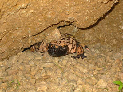
Figure 4. Gila
monster hiding
in a little alcove. The material making up the alcove consists of
cemented landslide debris on the east end of the slidemass.
|
How this virtual field
trip
works:
The field trip structure
involves a
series of stops with panoramic images of the surrounding terrain.
From these panoramic images, clickable hotspots provide a more in depth
means of examining particular locations of interest. After
exploring
all the hotspots for a particular spot, move on to the next stop and
repeat
the same procedure. A reference image located at the base of each
stop provides a viewshed of your current location, to help you maintain
your position with respect to eh landslide. The color rounded
triangle
represents the viewshed, you virtually stand at the pointy end and look
our towards the rounded edge (Figure 5). Along the way, more in
depth
information provides those so inclined a chance to explore in great
detail
some aspects of the Marcus Landslide, but by no means required to enjoy
your trip.
|
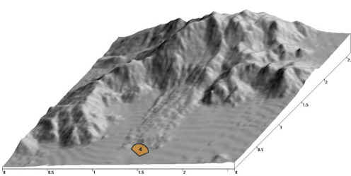
Figure 5. The upper
image is
an example of the guidance on this virtual field trip.
The funny pie shaped
feature with a
number is the viewshed you will see at, in this example, stop 4.
At this location, you are virtually standing in the pointed part of the
orange viewshed and looking out towards the rounded edge. In this
example, the photograph is what you would see from site 4, looking up
at
the bottom of the slide. The combination of aerial view and
ground
view helps you know where you and helps you navigate the field
trip.
The upper image was generated using MicroDEM.
|
|
|