NAVIGATION: BACK TO MODULE TWO INTRODUCTION
Where are we going on this module?
Arizona Section | Utah Section
Basically, through the course of this module, we will be exploring a large chunk of the central section of the Colorado Plateau. The Colorado Plateau is a physiographic "province," a region distinct from other parts of the West. Originally named "the Colorado Plateaus" by explorer John Wesley Powell, the "Plateau" is in fact a huge basin surrounded by highlands and filled with plateaus. We cover parts of Northern Arizona and Southern Utah (though the Colorado Plateau covers parts of Colorado and New Mexico, we do not venture to these states).
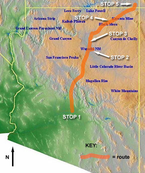
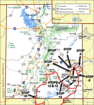
The two maps below (Arizona Section and Utah Section) show a rough outline of our route. Other maps found throughout the module show your location more specifically. Image at left shows general location of the Colorado Plateau (area outlined with white line).
Stops in Arizona include:
#1 - ASU Map Collection
#2 - Wupatki (near Flagstaff)
#3 - Painted Desert
#4 - Potholes and Rills (near Kayenta)
#5 - Monument Valley
Good Arizona links are here:
Stops in Utah include:
#6 - Beehive sandstone feature, near Moab
#7 - Groundwater Sapping, near Arches National Park
#8 - Fins overlook, near Deadhorse State Park
#9 - La Sal Mountains, near Moab
#10 - Arches National Park and Bridges National Monument
#11 - Typical scarps, near Arches NP
#12 - Upheaval Dome, Canyonlands National Park
#13 - Grand View, White Rim, Canyonlands National Park
#14 - Dirty Devil River
#15 - "The Wave" - Grand Staircase-Escalante National Monument
Good Utah links are here: