|
Follow the Water Stop 3 of 13 (Site 3b) |
|
|
NAVIGATION: BACK TO STOP 3 MAIN PAGE
| GPH 211 - GEOMORPHOLOGY |
| MODULE FIVE - FOLLOW THE WATER |
|
Follow the Water Stop 3 of 13 (Site 3b) |
|
|
|
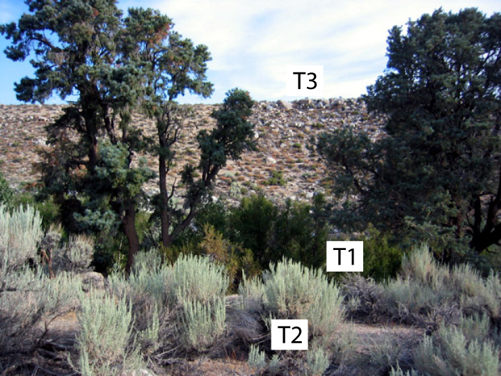
Follow the Water Stop 3 of 13 (Site 3b) Floodplain
and Terraces: The
upper image looks down on the Lone Pine Creek floodplain. The
creek
is
looping over to the left side of the image and an undulating floodplain
is obvious
in the middle of the image. The floodplain actually hugs close to
the
creek, and bordering the creek are series of two low terraces (by low,
which
means I am not referring to the obvious terrace (T3) that looms high over
the
creek). In the field, we clue into breaks in vegetation to help differentiate the different terrace levels. For example, Pine trees grow on the floodplain and the lowest terrace (T1). The next terrace (T2) is too high for the roots of trees to reach the water table, and so the vegetation is low sagebrush seen in the foreground of the lower image. When Lone Pine Creek floods big, water floods the floodplain and probably makes it to the roots of the pine trees, but probably never to the sagebrush. The 3 stream terraces that border Lone Pine Creek indicate the fluvial system has incised into its own alluvium (river sediment) in the past. To make such an incision requires an increase in stream power that can come from a variety of environmental changes. Climate change to a wetter climate or a climate with intense thundersorms, cattle compacting the ground, glacier melting, sudden draining of lakes, or a sudden drop in the elevation of a larger stream and other ideas have been proposed as hypotheses to explain these types of terraces. What do you think caused Lone Pine Creek to cut into its ancient floodplains and also led to streams with the power to carry such large boulders? |