NAVIGATION: BACK TO MODULE FIVE INTRODUCTION
Arthur Strahler (1918-2002) and Superimposition proposed 1948
Arthur Strahler and his brother Alan authored several textbooks on physical geography over the years. I used one of their textbooks when I took intro physical geography as an undergraduate. But before his textbook days, he published several landmark papers in geomorphology, including a paper on the eastern Grand Canyon region. He analyzed landslides coming off the Vermillion and Echo Cliffs and determined their rate of retreat. He looked at fracture patterns on the Kaibab Plateau and described the basic morphology of eastern Grand Canyon. Strahler, aware of the "Muddy Creek Problem" and the need for new ideas, proposed "superimposition" to explain Grand Canyon incision. Powell first described the superimposition mechanism for transverse drainages, but didn't propose it for Grand Canyon. Strahler adopts the idea and explains in more detail how superimposition would have worked to cut Grand Canyon.
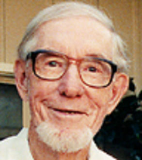

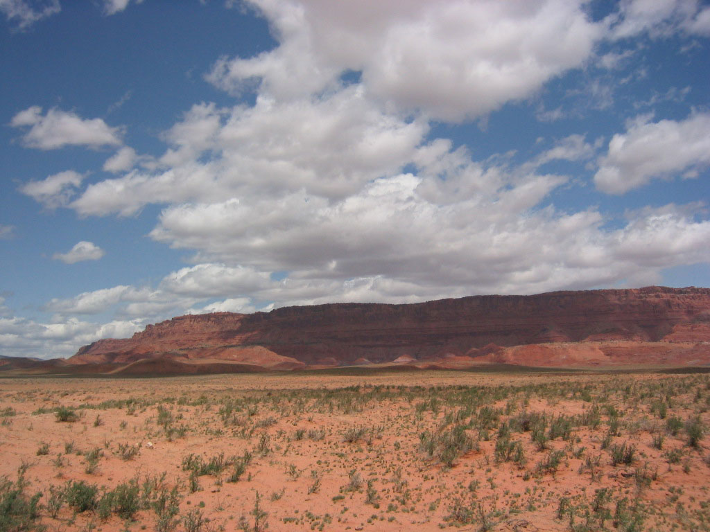
Figure 1. Strahler in his office in the left image, a cover from one of his textbooks in the middle image, and to the right the Vermillion Cliffs in northern Arizona.
Superimposition, more difficult to explain than antecedence and overflow, requires an overview of "erosional scarps". The Colorado Plateau consists mostly of nearly flat lying sedimentary rocks that include: sandstones, siltstones, claystones, and limestones. Sandstone and limestone resist weathering significantly more than clay and siltstones in an arid climate. So basically if a stack of limestone and sandstone sat next to a stack of clay and siltstones on the Colorado Plateau, the stack of limestone and sandstone would last much longer than the clay and siltstone. If rock weaknesses (such as faults and fractures) expose rock layers on the Colorado Plateau, the weaker clay and siltstones weather and erode more quickly and undermine any overlying resistant sandstone and limestone layers. As a result, a package of rock layers retreat away from the rock weakness. The thickness, weathering rate, and erosion rate of the weak units controls the rate of retreat.
Picture a layer of graham crackers sitting side by side on a tray. Now imagine a layer of melted chocolate is spread over the crackers (YUM!). We now have a tray of chocolate covered graham crackers, but by pushing your finger into your cracker pie you simulate a rock weakness, fracturing and faulting. If you would then sprinkle water over this tasty analogy, the graham crackers would weather much more readily than the chocolate at the weakness you generated with your fingers. If the weathered graham cracker could be transported off the tray, the missing graham cracker destabilizes the overlying chocolate layer and fails. Over time, the cracker and chocolate layers would retreat horizontally away from your original finger generated area of weakness.

Figure 2. A scarp on the Colorado Plateau, the bright red rock weathers more readily then the above dark red rock layer. After the bright red layer weathers and erodes, the undermined dark red layer fails as a pile of boulders.
The Kaibab Plateau uplifted along an anticlinal axis during the compressional Laramide Orogeny. As the plateau lifted, tensional stress along its apex or highest ridgeline broke the rock up into a series of fractures (you can see some big ones in the image below, in the snow just north of Grand Canyon). Here's an analogy, put your hand beneath a pancake (you can try this at home) and then form a fist. As the pancake lifts it cracks as the top of the pancake as its pulled apart from tensional stress. The same thing happened to the Kaibab Plateau. These cracks or weaknesses allowed scarps to retreat off the Kaibab Plateau.
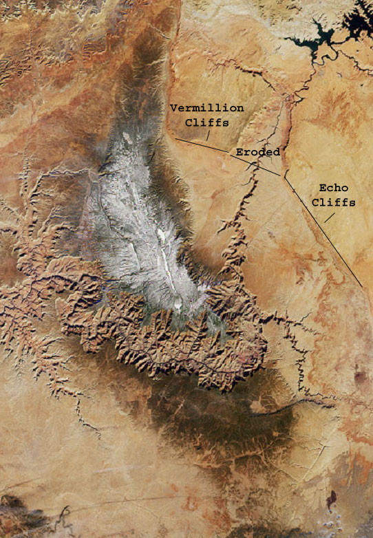
Figure 3. The linear features or fractures (filled with snow) on the Kaibab Plateau formed as the mountain uplifted. These initial weakness allowed scarps to retreat away from the plateau. The Vermillion and Echo Cliffs represent the latest scarps to retreat away from the fractures atop the Kaibab Plateau.
So the story so far, the Kaibab Plateau uplifted between 70 and 40 million years ago. Tensional fractures developed along the plateau's apex and allowed water to seep into and weather the weaker silt/claystone layers below. Erosion of these layers undermines the more resistant rock units above and erosional scarps or cliffs begin to retreat away from fractures atop the Kaibab Plateau. 70 to 40 million years allowed numerous scarps to retreat away from the Kaibab Plateau, and some currently reside to the north as the Grand Staircase. The impressive scarp face found at Bryce Canyon National Park represents the highest scarp and probably the first to retreat. The youngest scarps to retreat are the Vermillion and Echo Cliffs off the eastern edge of the Kaibab Plateau.
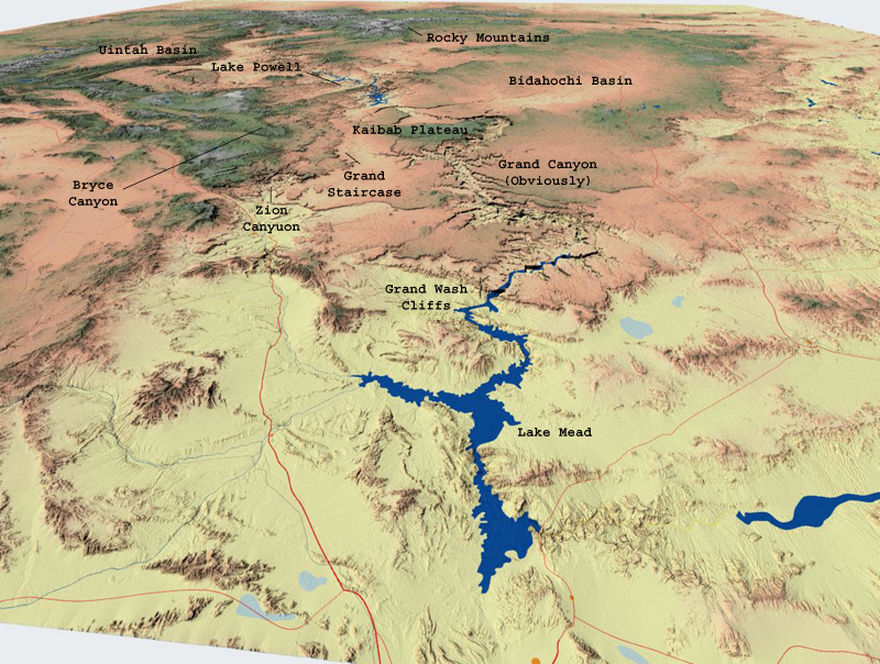
Figure 4. A favorite of mine, the Grand Staircase is visible to north of the Kaibab Plateau.

Figure 5. A view of Bryce Canyon, though it is actually a scarp and not a canyon.
So getting back to superimposition, Strahler envisioned retreating scarps burying the Kaibab Plateau's southern flank in soft sediment. The sediment would have acted as a ramp allowing the Colorado River to flow across the Kaibab Plateau. The sediment ramp could not have simply been flat but higher to the east and lower to the west across the Kaibab Plateau. This would allow the Colorado River to flow across the partially buried Kaibab Plateau without ponding in a lake. The scarps retreated in a circular fashion and controlled the river's position, which explains the big southward bend of the Colorado River across the Kaibab Plateau. After the river became established, a drop in base level (possibly associated with the opening of the Gulf of California) caused the river to incise dramatically. Over time, the river erodes into the scarp-derived soft sediment ramp and cuts deeply into the Kaibab Plateau's southern flank. Eventually, the softer sediment ramp is removed as the Colorado River becomes superimposed across the more resistant Kaibab Plateau. The diagrams below help visualize this process.


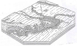
Figure 6. These drawings by Strahler help illustrate his vision of superimposition.
Strahler's superimposition hypothesis was the first to account for the Colorado River's southern bend across the Kaibab Plateau, the first mechanism to do so. With antecedence, the river couldn't have been controlled by the doming structure, because the river would've already become entrenched before the dome took shape. Superimposition accounts for the "Muddy Creek" problem because the river needs to be younger than the uplift of the Kaibab Plateau (but older than the most recent exposure of the southern Kaibab Plateau) for the mechanism to work. Superimposition gained little following in the scientific community for many years. Recently, however, Joel Pederson is bringing superimposition back to the table for further reconsideration. His recent article can be read here. The next hypothesis proposed after superimposition won over numerous scientists and still discussed widely today as a viable mechanism to explain Grand Canyon--stream piracy.