|
|
|
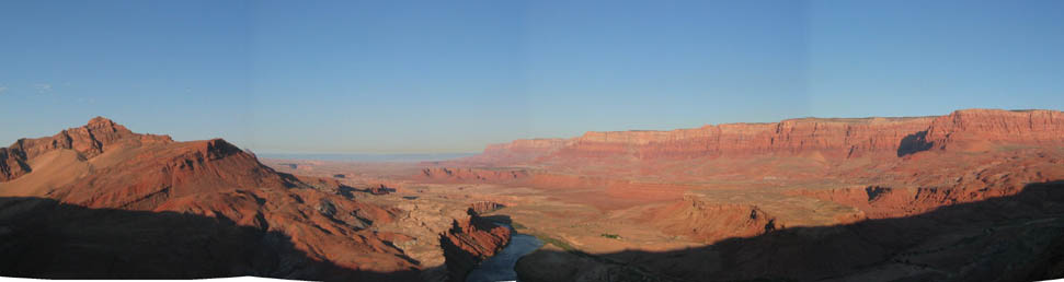
Introduction to "Grand Canyon" For a geomorphologist, and for most other people, Grand Canyon represents the iconic example of the term "erosion". Over one mile deep and over 200 hundred miles long, the canyon is visited by nearly 5 million visitors every year. This virtual field trip will look at the different ideas or hypotheses proposed by numerous geoscientists over the past 150 years to explain how the canyon formed. The planet is littered with canyons mostly cut by rivers, the Colorado River flows along the bottom of the Grand Canyon, so why isn't the answer to how the canyon formed simply, "uh... the Colorado River cut the Grand Canyon"? The answer is visible in the image above. The Colorado River is visible in the lower middle portion of the image and as look into the distance, you see the very beginning of Grand Canyon getting higher and higher downstream. So wait, the river flows downhill or downstream into a canyon that is getting deeper and deeper.... wouldn't that be like a river flowing into a MOUNTAIN or something.
|
|
How can a river flow through a mountain... that's weird. And that is what you are trying to figure out. The GOAL here is for the student to gather evidence from the virtual field trip to support one of the four proposed hypotheses: overflow, piracy, superimposition, antecedence. What are these, read through the introduction pages first before going into the exploratory trip of the Grand Canyon, below. |
|
Great
Fly Through of the Grand Canyon (Big File 20mb)
|