Welcome!!!
|
GPH
211 - Follow the Water: Mt. Whitney to Death Valley, CA
|
Welcome!!!
|
Introduction
to "Follow the Water" An
introductory lab science class must aid in student mastery of the basic
scientific principles and concept, in this case, of the field of
geomorphology. An SQ class must also address knowledge of the
scientific method and in doing so must cover methods of scientific
inquiry that characterize geomorphology, and yet also examine potential
for uncertainty. The SQ stands for Science Quantitative, and so
an SQ class must illustrate the usefulness of mathematics in scientific
description and reasoning.
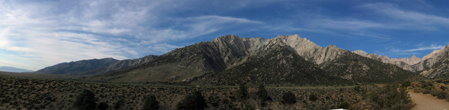
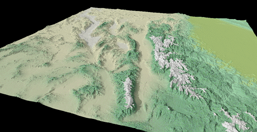
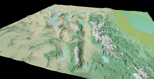
All of these basic aspects of a lab science class are reinforced through a virtual trip to eastern California. California hosts the highest point in the continental United States, Mt. Whitney. It also hosts the lowest point in North America, Death Valley. During past ice ages, amazingly enough, water flowing off of Mt. Whitney drained into a series of lakes that overfilled a number of sequential basins eventually draining into Death Valley. Compare the two images below, one shows the basins as they appear today, the other shows the basins filled with lakes that connected Mt. Whitney and Death Valley. |
 |
 |
|
In
this field trip, we are going to "Follow the Water" taken by these
ice-age streams and travel from Mt. Whitney to Death Valley. The
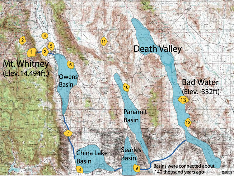
map
below illustrates our trip and provides a "birds eye" view of our
route. We start at Mt. Whitney and will slowly make our way to
Death Valley. As we go along, we are going to review
geomorphology processes found in mountain and arid environments.
However, before you start, watch some movies made by Professor William Bowen of Cal State Northridge. The first half of this movie "flies" over this region, and most of this movie covers our study region. Here is a primer of the topics to be covered (UNDERLINED refers to the stops associated with the grain size exercise and BOLDED refers to the different basins that needed to consecutively fill up and spill into each other to allow water to flow from Mt. Whitney to Bad Water, the lowest point in Death Valley): STOP 1: Glacial Landforms and Processes (Highest mountain environments) "Mt. Whitney" STOP 2: Fluvial Landforms and Processes (High mountain environments) STOP 3: Fluvial Landforms and Weathering (Exiting the mountain front) Grain Size Exercise Part 1 STOP 4: Meandering River From Above STOP 5: Mono Lake and Owens River ( Water Issues) Grain Size Exercise Part 2 STOP 6: Owens Playa Grain Size Exercise Part 3 STOP 7: Volcanism in Owens Valley and Erosion from Lake Overflow STOP 8: China Lake (playa) OFF LIMITS - AREA 51 and UFO stuff STOP 9: Searles Lake (playa) Salt Crystals and Tufa Towers STOP 10: Panamint Basin (playa) Alluvial Fans, Sand Dunes, and Rock Varnish STOP 11: RACETRACK PLAYA!!! Mudcracks and Racing Rocks STOP 12: Death Valley (playa) Alluvial Fans (again), Ventifacts, and Paleo-shorelines STOP 13: Death Valley (playa) Alluvial Fans (again), Fault Scarp, Crystillization "Bad Water" |
 |
|
Virtual Field Trip Follow the Water: Follow the Water; Mt. Whitney to Death Valley, CA |